Nilgiri
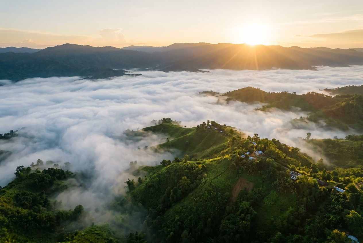
Sunrise above a sea of cloud in the Bandarban hills
Overview
Nilgiri is a hilltop destination in the Bandarban hill range of the Chattogram Hill Tracts, sitting at around 2,200-2,500 feet above sea level and named after the famous Indian hill station. A few kilometres east of Bandarban town, it is reached by a winding, military-managed road that climbs steeply through forest and tea gardens, ending at an army-run rest-and-recreation resort with simple rooms and a small tea stall.
The signature experience at Nilgiri is the dawn. Travellers gather on the ridge to watch the sun rise above a sea of cloud that fills the valleys below, while the peaks of the surrounding hill range emerge like islands in a white ocean. The cool, misty weather at the top contrasts sharply with the heat of the plains, and temperatures can drop noticeably even in the warmer months, lending the place an almost highland character.
On a clear day the view stretches a remarkable distance, taking in the Sangu river below and the distant hills of Ruma, Thanchi and the Myanmar border zone. Nilgiri is one of the most popular day trips from Bandarban town and a long-standing favourite for photographers, drawn by the interplay of cloud, light and ridge lines that changes with every hour of the morning.
Most visitors come for a few hours to catch the sunrise and return to Bandarban town by late morning, though a small number stay overnight in the basic army-run rooms. The hilltop is reached in roughly 30-40 minutes by Chander Gari or car, with the route partly military-controlled and subject to curfews, so carrying photo ID is advisable.
History & Culture
Nilgiri takes its name from the celebrated Indian hill station of the same name, reflecting the long tradition across South Asia of seeking out high, cool retreats within reach of the lowland heat. Within Bangladesh, it has become one of the recognised hilltop vantage points of the Bandarban range in the Chattogram Hill Tracts.
Today the hilltop is managed by the Bangladesh Army as a rest-and-recreation resort, a legacy of the military presence that has long administered access roads in the region. This has shaped the visitor experience: simple accommodation, a tea stall, controlled access and a route partly guarded by checkpoints.
Top things to do in Nilgiri
Watch the sunrise from the ridge
Arrive before dawn and watch the sun rise above a sea of cloud that fills the valleys below, with the peaks of the hill range rising like islands. It is the signature experience of Nilgiri and the reason most visitors make the early climb.
Photograph the cloud sea and peaks
Set up on the hilltop for sweeping shots of the mist-filled valleys and the distant ridges. The interplay of cloud, light and mountain silhouettes changes by the minute, rewarding both early and later risers.
Take in the long-distance views
On a clear day, scan the horizon for the Sangu river below and the distant hills of Ruma, Thanchi and the Myanmar border zone. Binoculars help pick out landmarks across the Chattogram Hill Tracts.
Enjoy a cup of tea at the hilltop stall
Warm up with a hot drink at the simple tea stall on the ridge, the social heart of the hilltop. The contrast between the cool breeze and a steaming cup is part of the morning ritual.
Descend through forest and tea gardens
The drive back down the winding hill road passes forest and tea gardens on its way to Bandarban town. Pause at viewpoints along the way to watch the cloud sea slowly dissolve as the day warms.
Nilgiri in pictures


Photos via Wikimedia Commons under their respective Creative Commons licences. Click a photo credit for the source and full licence terms.
Highlights
- ✓Sunrise above a sea of cloud filling the valleys
- ✓Panoramic views over the Sangu river and distant hills
- ✓Cool, misty weather high above the plains
- ✓Military-managed hill road through forest and tea gardens
- ✓Vistas towards Ruma, Thanchi and the Myanmar border
- ✓Favourite dawn spot for photographers
How to get to Nilgiri
The most common route is from Bandarban town, about 30-40 minutes up the steep, winding hill road in a Chander Gari (open-top jeep) or a car. The road is partly military-controlled and may have curfews, so travel in the morning and carry photo ID.
Visitors travelling from Chattogram typically take a bus or jeep to Bandarban town and continue to Nilgiri the following morning. Many combine the hilltop sunrise with time exploring Bandarban town and surrounding trails.
Local operators in Bandarban town run early-morning guided trips to Nilgiri timed for the sunrise. Tours usually include transport up the military road, a stop at the tea stall and return to Bandarban by late morning.
Best time to visit Nilgiri
October to March is widely regarded as the best window, with drier weather, crisp morning light and the most reliable cloud seas at sunrise. Clear days also open up long views over the Sangu river and the distant hills towards the Myanmar border.
The monsoon months bring heavy mist, low cloud and a slippery hill road, making the journey to the top more challenging. Travellers who do visit during this season should allow extra time and expect the cloud sea to be present even after sunrise.
Even in the warmer months the hilltop stays noticeably cooler than the plains, and temperatures can drop sharply in the early hours. Warm clothing is recommended at any time of year for the dawn visit.
Where to stay
Accommodation on the Nilgiri hilltop is limited to very basic army-run rooms that should be booked in advance. Most travellers stay in Bandarban town and visit the hilltop for an early-morning sunrise trip, returning by late morning.
What to eat
- 🍽️Hot tea from the hilltop tea stall
- 🍽️Simple local breakfasts at Bandarban town before the climb
- 🍽️Snacks and biscuits carried up for the sunrise
- 🍽️Traditional tribal dishes available in Bandarban town
Travel tips
- 💡Start before dawn to reach the ridge in time for sunrise
- 💡Carry warm clothing as it is much cooler at the top than in the plains
- 💡Bring photo ID for the army checkpoints on the hill road
- 💡Travel in a Chander Gari or sturdy vehicle on the steep, winding road
- 💡Check for any curfews or restrictions on the military-controlled route before setting off
Nearby Attractions
Frequently Asked Questions
Where is Nilgiri in Bangladesh?+
Nilgiri is a hilltop destination in the Bandarban hill range within the Chattogram Hill Tracts. It sits a few kilometres east of Bandarban town, accessed by a winding military-managed road that climbs through forest and tea gardens.
How high is Nilgiri above sea level?+
Nilgiri sits at around 2,200-2,500 feet, or roughly 670-760 metres, above sea level. This elevation gives it noticeably cooler and mistier weather than the lowland plains of Bangladesh.
How do I get to Nilgiri from Bandarban?+
From Bandarban town it takes about 30-40 minutes to reach the hilltop by Chander Gari (open-top jeep) or car. The road is steep and partly military-controlled, with checkpoints where you will need to show photo ID.
When is the best time to visit Nilgiri?+
October to March is the best time for the clearest sunrises and the most reliable cloud seas. The monsoon brings heavy mist and a slippery hill road, so the journey is best attempted in the dry season.
Can I stay overnight on Nilgiri?+
A small number of simple army-run rooms are available on the hilltop and should be booked in advance. Most visitors, however, come for the sunrise and return to Bandarban town by late morning.