Keokradong
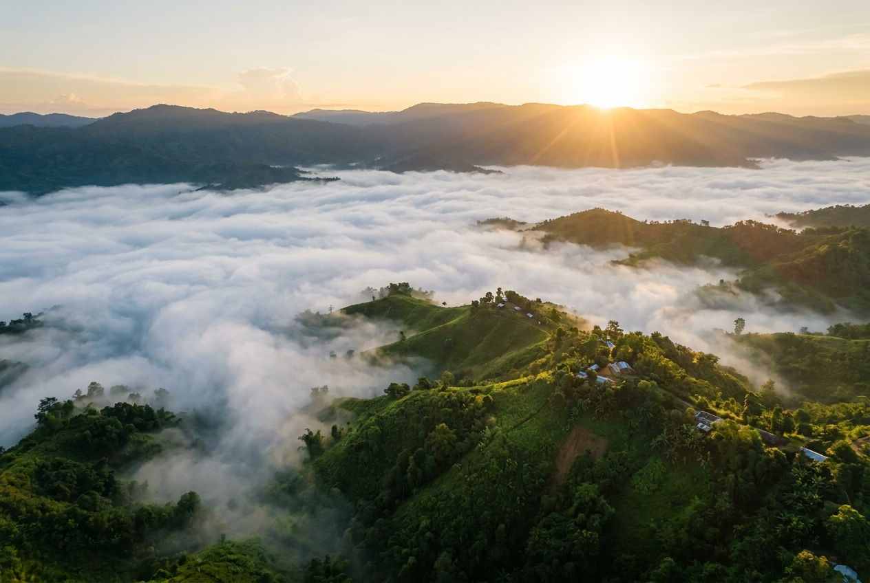
Sunrise above the clouds on Bangladesh's highest peak
Overview
Rising from the forested ridges of the Ruma upazila in Bandarban district, Keokradong is one of the most celebrated trekking peaks in the Chittagong Hill Tracts. Long cited as the highest peak of Bangladesh, it draws hikers looking for a relatively accessible high-altitude adventure in a country better known for its flat alluvial plains. The climb rewards visitors with sweeping panoramas across layered green hills, the curling rivers of the Hill Tracts, and, on a clear day, a distant shimmer of the Bay of Bengal.
Most trekkers begin the journey from the small town of Ruma, where local operators arrange the necessary registered guides. The route threads through jungle, bamboo groves and indigenous villages before climbing to a simple shelter near the summit. A long day can see hikers up and back, but most choose to camp overnight so they can greet the sunrise from the top, when the surrounding hills often float above a sea of cloud.
Keokradong is far more than a physical challenge. The surrounding Ruma area is the homeland of the Mro and other indigenous communities of the Chittagong Hill Tracts, and a registered local guide is mandatory for both the trek and visits to nearby villages. Travelling slowly, with respect for local customs, turns the climb into a rich cultural encounter as well as a memorable mountain day.
Reaching the summit means navigating rough jeep tracks, monsoon-slicked trails and very basic accommodation, but the sense of arrival makes every step worthwhile. Whether you come for the sunrise, the views, or the chance to learn about the highland communities, Keokradong offers one of the most rewarding mountain experiences available in Bangladesh.
History & Culture
Keokradong sits in the Ruma upazila of Bandarban district, deep in the Chittagong Hill Tracts, and is widely cited as the highest peak of Bangladesh. The exact figure is debated, with elevations of around 986 to 1,230 metres (3,170 to 4,034 feet) recorded depending on which summit marker is taken as the highest point. In 1993, a unit of the Bangladesh Army laid a stone plinth at the summit, which still marks the high point and serves as a focal point for trekkers reaching the top.
The mountain takes its name from local languages, though the meaning remains debated. One tradition links 'Keokradong' to the Marma word for a flowering bamboo, while another popular etymology ties the first part of the name to a stone, 'kheong', and the Mro word for climbing with a rope. Whichever interpretation is favoured, the name reflects the deep linguistic heritage of the indigenous communities who have long considered these highlands home.
Top things to do in Keokradong
Summit the peak for sunrise
Most trekkers time their climb to reach the top in time for dawn, when the surrounding hills often rise above a sea of cloud. Watching the sun break over the Hill Tracts from the stone plinth is the trip's defining moment.
Trek from Ruma through jungle and bamboo
The trail from Ruma winds through dense forest and bamboo groves, with changing views as the path climbs. The four-to-six-hour ascent and three-to-five-hour descent make it a satisfying but manageable day for reasonably fit hikers.
Camp overnight at the simple summit shelter
A basic shelter near the top allows trekkers to sleep close to the summit and be on the plinth at first light. Visitors should carry their own food, water and sleeping gear as facilities are extremely limited.
Visit nearby indigenous villages with a local guide
The Ruma area is home to the Mro and other indigenous communities, and a registered local guide is mandatory for both the trek and village visits. A guide will also help interpret customs and arrange respectful encounters.
Take in the panoramic Hill Tracts views
From the summit, layered ridges of the Chittagong Hill Tracts roll away in every direction, and on a clear day the Bay of Bengal is visible in the distance. The vastness of the view is a striking contrast to Bangladesh's lowland plains.
Keokradong in pictures


Photos via Wikimedia Commons under their respective Creative Commons licences. Click a photo credit for the source and full licence terms.
Highlights
- ✓The stone summit plinth laid in 1993 marking one of Bangladesh's highest points
- ✓Panoramic sunrise views over the Chittagong Hill Tracts and, on a clear day, the Bay of Bengal
- ✓An overnight camp at a simple shelter near the summit for a true high-altitude experience
- ✓Trekking through the jungle and bamboo groves of Ruma upazila
- ✓Encounters with Mro and other indigenous communities of the Hill Tracts
- ✓A relatively accessible high-altitude trek within Bangladesh
How to get to Keokradong
From Bandarban town, travellers continue to Ruma by Chander Gari (open jeep) on rough hill roads, a journey of around four to six hours depending on conditions. The road is bumpy and can be slow in or after rain, so an early start is advisable.
From Ruma, the trek to the summit takes roughly four to six hours up and three to five hours down. Many trekkers break the journey with an overnight at a simple shelter near the top, which also allows a sunrise finish.
Most visitors reach Bandarban from Chattogram by road, with onward connections from Dhaka by bus or domestic flight to Chattogram. From Bandarban, the onward journey to Ruma and then the trail is as described above.
Best time to visit Keokradong
Winter, from November to February, is the prime trekking season, with cooler temperatures, firmer trails and the clearest panoramas across the Hill Tracts. This is when the sunrise views from the summit are at their most rewarding.
The shoulder months on either side of winter can still work, but conditions become less predictable as the rains approach or recede. Trail conditions, water levels and visibility can change quickly during these transitions.
The monsoon, roughly June to September, makes the trail very slippery and prone to erosion, while leeches and heavy cloud can hide the views entirely. The monsoon is generally considered unsuitable for the standard Keokradong trek.
Where to stay
Accommodation is very basic, with simple guesthouses in Ruma town and a simple shelter near the summit. Most visitors carry their own food and water, and trekkers camping overnight at the top should bring a sleeping bag and warm layers.
What to eat
- 🍽️Local rice and dal served in Ruma's small eateries and guesthouses
- 🍽️Simple boiled eggs, biscuits and noodles carried up from Ruma for the summit camp
- 🍽️Fresh hill-stream fish where available in Ruma
- 🍽️Tea and local snacks at roadside stops along the Bandarban to Ruma jeep route
Travel tips
- 💡Arrange the trek with a registered local operator in Bandarban or Ruma, as a guide is mandatory.
- 💡Carry sturdy boots, rain protection, a warm layer for the summit night, and basic first aid.
- 💡Bring sufficient food and drinking water, as supplies are very limited above Ruma.
- 💡Expect patchy or no mobile signal on the trail and at the summit.
- 💡Respect indigenous customs and always ask before photographing people in the villages.
Nearby Attractions
Frequently Asked Questions
Is Keokradong really the highest peak in Bangladesh?+
Keokradong is widely cited as the highest peak of Bangladesh, with elevations of around 986 to 1,230 metres (3,170 to 4,034 feet) recorded depending on which summit marker is taken as the highest point. The exact figure is debated, but it is generally regarded as one of the country's topmost points.
Do I need a guide to trek Keokradong?+
Yes. A registered local guide is mandatory for the Keokradong trek and for visiting nearby indigenous villages. Guides can be arranged through local operators in Bandarban or in Ruma town, where the trail begins.
How difficult is the Keokradong trek?+
The climb is considered one of the more accessible high-altitude treks in Bangladesh, but it is still a full mountain day. From Ruma, expect roughly four to six hours up and three to five hours down, with steep and, in places, slippery sections.
When is the best time to visit Keokradong?+
The dry winter, from November to February, is the best time to trek Keokradong, when trails are firm and the views are at their clearest. The monsoon makes the trail very slippery and is generally avoided by trekkers.
What are the accommodation options on the trek?+
Accommodation is very basic, with simple guesthouses in Ruma and a simple shelter near the summit. Most visitors carry their own food, water and sleeping gear, and many spend a night at the top to catch the sunrise.